|
"Indian Land Access" |
|
How many acres of land are there in
Wisconsin... answer 35,011,200 acres! 2nd question... who owns it?
Here are the interesting answers... |
|
Lac Courte Oreilles Tribal Land (Sawyer
County): There are only 2 know waterways of interest
on the Lac Courte Oreilles Tribal Land... Pipestone Falls and Billy Boy
Flowage Spillway. Pipestone Falls is on tribal land and is not
accessible to the general public... the land in that area is considered sacred
and unless you are a member of that tribe you are not allowed to view the
falls. There is a story (don't know if it is true) that a person parked
on County Road "H" and walked the trail to see the falls... he was caught by
Tribal Police and they kept his vehicle as a fine for trespassing on tribal
land. Whether it is true or not is immaterial... Tribal Police have
ultimate power to enforce tribal laws... so do not trespass on tribal land! |
|
Bad River Tribal Land (Ashland & Iron
Counties): There is only 1 known waterway of interest on Bad River tribal land... Bad River Falls in Ashland County. There are undoubtedly other falls and rapids of interest but they would be on tribal land and not accessible unless you are a member of that tribe. If you walked downstream along the Bad River from Brownstone Falls in Copper Falls State Park for 6 miles you would enter Bad River Tribal Land. Copper Falls State Natural Area abuts the Bad River Tribal Land. Again... do not trespass on tribal land! |
|
Potawatomi Tribal Land (Forest County): We currently do not know of any waterfalls, spillways or rapids that are on any of the Potawatomi tribal lands. We do have several places on our list of places to check for rapids in the Rat and Peshtigo Rivers... if we find that those locations are on tribal land we will so indicate on the write-ups for those locations. Trespassing on any Indian tribal land, just like any
privately owned land, is illegal unless you have obtained permission to
trespass. |
|
|
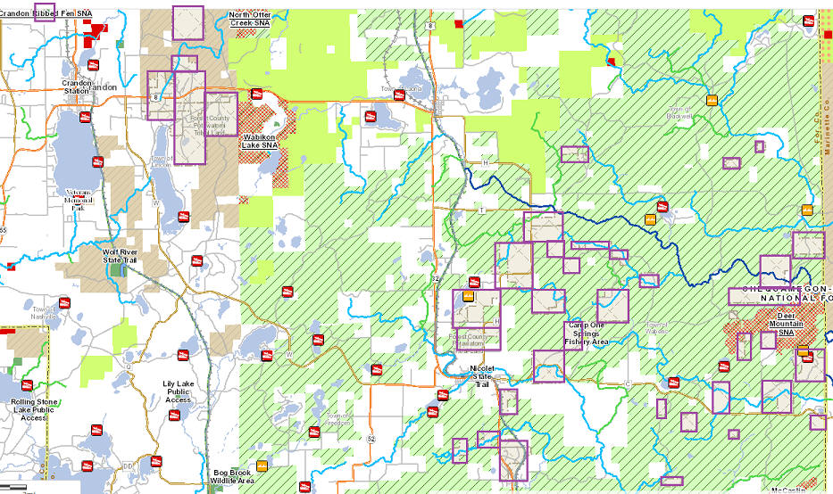
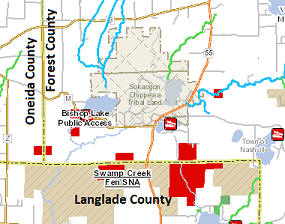
Sokaogon Chippewa Community (Mole Lake
Band) Tribal Land (Forest County): We currently do not know of any waterfalls, spillways or rapids that are on any of the Sokaogon tribal lands. Neither do we have any places on our list of places to check that are in that area. As we have said before... if you find a waterway that needs checking, please contact the tribal headquarters for permission before trespassing on tribal land.
|
|
Lac du Flambeau Band of Lake Superior
Chippewa Tribal Land (Vilas & Iron County): There is only 1 spillway on tribal land of the Lac du Flambeau Band of Lake Superior Chippewa Indians. Flambeau Lake Spillway is visible from Indian Village Road (a public road so you do not have to trespass on land to see the spillway). If you find a waterway that needs checking please contact the tribal headquarters if permission is needed to trespass on tribal land.
|
|
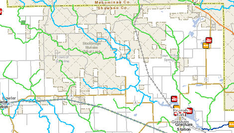
Stockbridge-Munsee Community Band of Mohican
Tribal Land (Shawano County): We currently do not know of any waterfalls, spillways or rapids that are on any of the Stockbridge-Munsee Community Band of Mohican Tribal Land. We do have several places on our list of places to check for rapids and or waterfalls in the West Branch of the Red River... if we find that those locations are on tribal land we will so indicate on the write-ups for those locations. If you find a waterway that needs checking, please contact the tribal headquarters for permission before trespassing on tribal land.
|
|
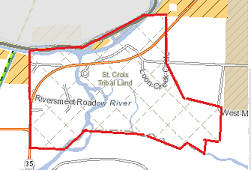
Saint Croix Chippewa Indians of Wisconsin
(Burnett County): We currently do not know of any waterfalls, spillways or rapids that are on any of the tribal lands of the Saint Croix Chippewa Indians. We do have one place on our list of places to check for rapids and or waterfalls in the Yellow River... if we find that those locations are on tribal land we will so indicate on the write-ups for those locations. If you find a waterway that needs checking, please contact the tribal headquarters for permission before trespassing on tribal land.
|
|
Red Cliff Band of Lake Superior Chippewa Tribal
Lands (Bayfield County): We currently do not know of any waterfalls, spillways or rapids that are on any of the tribal lands of the Red Cliff Band of Lake Superior Chippewa Indians. If you find a waterway that needs checking, please contact the tribal headquarters for permission before trespassing on tribal land.
|
|
Oneida Nation Tribal Lands (Brown and
Outagamie Counties): We currently do not know of any waterfalls, spillways or rapids that are on any of the tribal lands of the Oneida Nation tribal land. If you find a waterway that needs checking, please contact the tribal headquarters for permission before trespassing on tribal land.
|
|
Menominee Indian Tribe of Wisconsin
(Menominee County): Menominee County is designated by the State
of Wisconsin as "Tribal Land". Most land in Menominee County is owned
by the Federal Government, but is controlled by Menominee Tribal Headquarters.
In most cases, unless you are a member of the tribe you are not permitted to
travel or be on tribal land! In Menominee County that policy is enforced
in some areas and not in others, which makes it difficult to determine where
non-tribal members are allowed to travel. Example - we were told it was
OK to walk on tribal land to see Sullivan Falls but not allowed to drive to it
on the road. We were also told, in general, that access to falls and
rapids along the Wolf River is allowed (unsure what "in general" means).
Wisconsin state roads throughout the county
are obviously legal travel... to venture on other roads we suggest talking
to Tribal Headquarters in Keshana to get their approval. |
|
Ho-Chunk Nation Tribal Land (located in 14
counties in Wisconsin): Ho-Chunk does not have a reservation, but they own over 8,800 acres scattered throughout Wisconsin... small parcels in Adams, Clark, Crawford, Dane, Eau Claire, Jackson, Juneau, La Crosse, Marathon, Monroe, Sauk, Shawano, Vernon & Wood Counties in Wisconsin... they also have some land in the State of Illinois. We have no way of determining where all these parcels are located... so watch for signs that say access is prohibited. |
|
General comments: Information details discussed here are only opinions... not legal interpretations... we disclaim any liability for illegal access, injury or damage when visiting any of the places listed on this website.
|
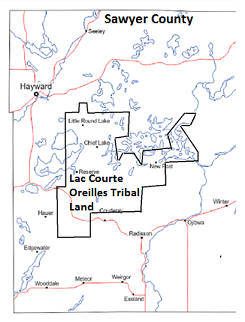 ...
the map also shows the 107 square mile area (54,000 acres) of Sawyer County that is
designated as Lac Courte Oreilles Tribal Land (we do not guarantee this map to
be 100% accurate... if in doubt about an actual area please contact the tribal
headquarters). The Lac Courte Oreilles Tribal Government headquarters is
located in Hayward at
...
the map also shows the 107 square mile area (54,000 acres) of Sawyer County that is
designated as Lac Courte Oreilles Tribal Land (we do not guarantee this map to
be 100% accurate... if in doubt about an actual area please contact the tribal
headquarters). The Lac Courte Oreilles Tribal Government headquarters is
located in Hayward at
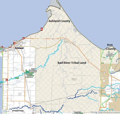 River Tribal Land (tribal land is shown
in gray... notice that some of the tribal land extends into Iron County).
River Tribal Land (tribal land is shown
in gray... notice that some of the tribal land extends into Iron County).
 tribal land area is 7 miles
southwest of Crandon. Tribal headquarters is at 3051 Sand Lake
Road, Crandon, Wisconsin 54520... telephone 715-478-7500.
tribal land area is 7 miles
southwest of Crandon. Tribal headquarters is at 3051 Sand Lake
Road, Crandon, Wisconsin 54520... telephone 715-478-7500. 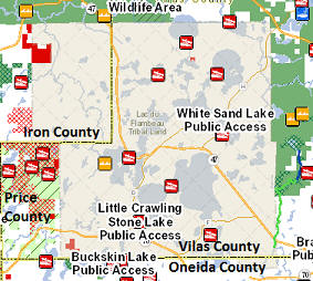
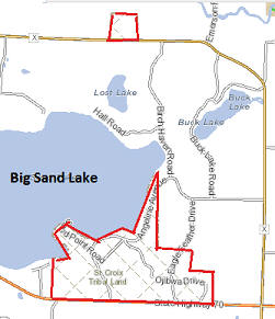
 left
is the area around Big Sand Lake in the south part of the county... the area
at right is in the north part of the county where the Yellow River empties
into the St. Croix River, just east of Danbury. The tribal headquarters
of the Saint Croix Chippewa Indians of Wisconsin is at 24663 Angeline Avenue,
Webster, Wisconsin 54893... telephone is 715-349-2195.
left
is the area around Big Sand Lake in the south part of the county... the area
at right is in the north part of the county where the Yellow River empties
into the St. Croix River, just east of Danbury. The tribal headquarters
of the Saint Croix Chippewa Indians of Wisconsin is at 24663 Angeline Avenue,
Webster, Wisconsin 54893... telephone is 715-349-2195.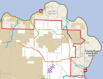 Indians.
The tribal headquaters of the Red Cliff Band of Lake Superior Chippewa Indians
is at 88455 Pike Road, Bayfield, Wisconsin 54814... telephone 715-779-3700.
Indians.
The tribal headquaters of the Red Cliff Band of Lake Superior Chippewa Indians
is at 88455 Pike Road, Bayfield, Wisconsin 54814... telephone 715-779-3700.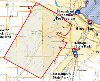 is at N7210
Seminary Road, Oneida, Wisconsin 54155... telephone 800-236-2214.
is at N7210
Seminary Road, Oneida, Wisconsin 54155... telephone 800-236-2214.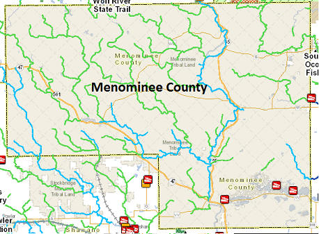 Road,
Keshana, Wisconsin 54135... telephone 715-799-5100.
Road,
Keshana, Wisconsin 54135... telephone 715-799-5100.