|
Wisconsin
Waterfalls "blog" |
|
Closures:
July 2017 --- The trails to Morgan Falls
and St. Peter's Dome were washed out in 2017... original projection was
that the trails would be open late
2017... the National Forest
people have just announced that the
current projection is that the trails
will be open in the spring of 2018...
update summer 2018, all trails are now
open!
August 2018 --- Pattison State Park... many trails and access to some of the
falls are closed because of severe damage caused by heavy rains in June and
August... as of May 2020 many trails and falls access are still closed...
update Sept 2020, all trails and falls are now
open!
June 2021 --- The access road to Gilmore Falls is closed... please advise us
when you see it is open. |
|
Comments:
(BC) Received my guide today and its awesome.
(JB) Thank you for your website!
(JW) I love your book...
(DC) Your supportive website is very nice...
(PF) Thank you for a wonderful waterfall guide!
(RB) Your guide is super with wonderful information...
(JS)
I’ve very much enjoyed your book. Thanks for your hard work,
and your attention to detail.
(AM) Most complete guide to waterfalls in Wisconsin...
|
(SS)
Awesome channel! Really helps out, thanks for the hard work
(DD) Wow, this video is amazing
(JJ) Love taking pictures there
(JP) Great video of the Merrillan waterfall
(JT) Keep up the good work
(J) Thank you
(DW) Love the extra "turn by" booklet |
|
Editorial Comments:
2-1-18
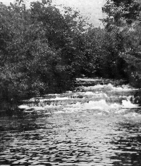 Shown
here is Tar Falls... the
picture shown here is from an old
postcard that labels it Tar Falls near
Sparta, Wisconsin but that is all we
have for a location. The
Wisconsin Historical Society also has
a post-card picture of the falls that
is quite similar and it also states
the falls are near Sparta, Wisconsin.
Searching on Internet we found a
location named “Tar Valley” that is
located about 2.7 miles north northwest of Tunnel City.
Further research on USGS maps show
that the Valley is named Tarr Valley
and runs the entire length of Tarr
Creek, so it is north as shown on
Internet, then runs southwest all the
way to its intersection with Sparta
Creek. Tunnel City is on Route
21 just northwest of Tomah, Wisconsin
and just east of Fort McCoy. We
talked with people at the Monroe
County Local History Room & Museum and
they told us about Tarr Creek which is
just west northwest of Tunnel City
(notice that the name is spelled Tarr
as opposed to Tar Falls as shown on
the postcard). To add a little more
confusion we found a 1887 map of
Monroe County that labels the creek as
Tarrs Creek (another different
spelling). We found another map
dated 1858 and the creek shown is not
named. An interesting area on
the 1887 map is labeled McCoil's
Mill... most mills of that era were
powered by water wheels; so it is very
possible that Tar (or Tarr or Tarrs)
Falls is near that spot. The
mill was located at the intersection
of Tarrs Creek and Sparta Creek 7
miles west of Tunnel City. The
1858 map also shows the mill at the
same location and it is named L. A.
Farr's Mills (cannot be sure that is
the name of the mill... it could just
be a landowner's name adjacent to the
mill). So, now we add Farr to
the Tar, Tarr, Tarrs confusion.
The big problem is that this mill is
located on what is now Fort McCoy
property and it is doubtful access is
available. We will continue to research the area in an attempt to
eventually find the falls (or determine that it no longer exists). In the
meantime, if anyone has more
definitive information about Tar Falls
and where it is located please send us
an email. Shown
here is Tar Falls... the
picture shown here is from an old
postcard that labels it Tar Falls near
Sparta, Wisconsin but that is all we
have for a location. The
Wisconsin Historical Society also has
a post-card picture of the falls that
is quite similar and it also states
the falls are near Sparta, Wisconsin.
Searching on Internet we found a
location named “Tar Valley” that is
located about 2.7 miles north northwest of Tunnel City.
Further research on USGS maps show
that the Valley is named Tarr Valley
and runs the entire length of Tarr
Creek, so it is north as shown on
Internet, then runs southwest all the
way to its intersection with Sparta
Creek. Tunnel City is on Route
21 just northwest of Tomah, Wisconsin
and just east of Fort McCoy. We
talked with people at the Monroe
County Local History Room & Museum and
they told us about Tarr Creek which is
just west northwest of Tunnel City
(notice that the name is spelled Tarr
as opposed to Tar Falls as shown on
the postcard). To add a little more
confusion we found a 1887 map of
Monroe County that labels the creek as
Tarrs Creek (another different
spelling). We found another map
dated 1858 and the creek shown is not
named. An interesting area on
the 1887 map is labeled McCoil's
Mill... most mills of that era were
powered by water wheels; so it is very
possible that Tar (or Tarr or Tarrs)
Falls is near that spot. The
mill was located at the intersection
of Tarrs Creek and Sparta Creek 7
miles west of Tunnel City. The
1858 map also shows the mill at the
same location and it is named L. A.
Farr's Mills (cannot be sure that is
the name of the mill... it could just
be a landowner's name adjacent to the
mill). So, now we add Farr to
the Tar, Tarr, Tarrs confusion.
The big problem is that this mill is
located on what is now Fort McCoy
property and it is doubtful access is
available. We will continue to research the area in an attempt to
eventually find the falls (or determine that it no longer exists). In the
meantime, if anyone has more
definitive information about Tar Falls
and where it is located please send us
an email. |
|
Old postcards:
We mentioned “old postcards” in the
paragraph above... we have found old
postcards to be an excellent source of
photographs of waterfalls. We
have started a collection of waterfall
postcards, most of which are in the
early 1900's and some back to 1887.
If you do a search on eBay you will
find quite a lot of early postcards. A
word to the wise... you seldom need to
pay what they are asking... most will
take a price much less than they
ask... we have never paid more than
$5.00. |
|
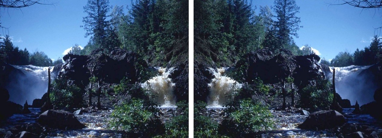
Mystery Photo (from private viewer 3-4-18): We have a photo of a
falls, submitted by a reader, that we cannot identify...
it was taken about 1965 and is
shown below... it was originally a
slide, so it could have been
reversed when printed... so the
picture may be either of the two
pictures shown below. The
falls are thought to be in
Wisconsin, but may be in
Michigan Upper Peninsula.
Can anyone help us identify where
the falls are??? Let us know
and the info will be forwarded to
the owner!
UPDATE --- A viewer thinks the
picture on the left may be Gabbro
Falls in Michigan! Can
anyone confirm???
 |
|
|
|
|
[Return to Home Page]
See Home Page for Miriah Systems LLC
Copyright information. All rights reserved
This website is casual informational only. Information on
these pages has been obtained from various sources, and is of
varying age, reliability and resolution.
No representation is made or warranty given as to the content
herein. No warranty, expressed or implied, is made regarding
accuracy, applicability for a particular use,
completeness, or legality of the information contained on this
website. User assumes all risk for use of all information on this website.
The Lat-Long GPS coordinates shown are not guaranteed and we assume no responsibility for any loss or delay resulting from
their use.
Data on this web site may not be reproduced in whole or in part in any manner.
|